Mapping the Expansion of Israeli West Bank Settlements
A new visual analysis is shedding light on the rapid expansion of Israeli settlements across the occupied West Bank and East Jerusalem. By utilizing…
Featured image for news article
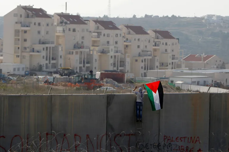
A new visual analysis is shedding light on the rapid expansion of Israeli settlements across the occupied West Bank and East Jerusalem. By utilizing interactive mapping, the data illustrates how these Jewish-only communities have evolved from scattered hilltop outposts into a sophisticated, interconnected network of infrastructure that physically segments Palestinian territories.
The geography of the region has been fundamentally altered over the last six decades. While some settlements trace their roots to the pre-1948 era, the pace of construction accelerated significantly following the 1967 occupation. Today, these areas, which often mirror modern suburban developments, stand in stark contrast to the surrounding Palestinian villages.
The Scale of Modern Settlement
Current data provided by the Israeli anti-settlement watchdog Peace Now highlights the sheer magnitude of the expansion. There are officially 148 settlements in the West Bank and 15 in East Jerusalem. These 163 locations serve as homes to approximately 750,000 Israeli settlers, representing nearly 10 percent of Israel’s total Jewish population.
The growth is not limited to new foundations but is driven by massive housing developments. In 2025 alone, authorities advanced nearly 28,000 housing units within existing settlements. This systematic densification strategy allows the state to expand its footprint significantly without the diplomatic friction often caused by establishing entirely new outposts.
Outposts and Legal Status
Beyond the officially sanctioned settlements, the landscape is dotted with more than 400 illegal outposts. Unlike the government-planned and funded settlements like Ariel or Maale Adumim, outposts are technically built without formal government authorization. However, critics argue these sites are frequently absorbed into the formal network over time, creating a complex and fluid reality on the ground.
The legal status of these communities remains a point of intense international contention. Under international law, the settlements are widely considered illegal, as they contravene the Fourth Geneva Convention. This treaty prohibits an occupying power from transferring its own population into territory under its control.
International Stance and Recent Developments
The International Court of Justice, alongside the United Nations Security Council and the International Committee of the Red Cross, has consistently affirmed that the settlement enterprise violates international humanitarian law.
This legal consensus was most recently reinforced by the advisory opinion issued by the International Court of Justice in July 2024. Despite these international rulings, the Israeli government continues to authorize and fund these communities, viewing them as a domestic policy matter rather than an international violation.
Beyond the structural growth, the region has seen a sharp rise in settler-led pogroms, which have reached record highs. These violent episodes, occurring alongside the physical expansion of infrastructure, have further complicated the security environment for Palestinians living in the vicinity of these sprawling hilltop communities.
As the network of highways and roads continues to bind these settlements closer to the Israeli interior, the prospect of a contiguous Palestinian state becomes increasingly difficult to visualize. The map serves as a stark reminder of how on-the-ground construction effectively reshapes regional geopolitics.